Dogpatch and Potrero Hill are sandwiched between two freeways: Highway 101 and Interstate 280. These roadways not only define local geography but create the conditions for a constant hum of traffic, toxic leaks from crumbling tires, oil, and other vehicle elements, and polluting air emissions.
To understand traffic’s contribution to air pollution, in 2010 the U.S. Environmental Protection Agency (E.P.A.) implemented a near-road air monitoring network. Originally designed to study nitrogen dioxide (NO2) levels, the system has grown to measure numerous other pollutants emitted by gasoline and diesel-powered vehicles, such as ultrafine particles and fine particulate matter (PM2.5), carbon monoxide (CO), black carbon (soot), and volatile organic compounds (VOCs). According to E.P.A., these contaminants can increase risks associated with cancer, cardiovascular disease, asthma, and premature death.
As part of this national network, the Bay Area Air Quality Management District (BAAQMD) operates four near-road sites, one at 16th and Arkansas streets, three alongside Bay Area freeways with high traffic counts. Hourly average NO2 and PM2.5 concentrations at the three freeway adjacent sites – Oakland – Laney, Berkeley Aquatic Park, and San Jose – Knox –mostly peak in the morning and evening, during rush hours. Intensities at the Potrero Hill location show the same pattern, but at levels lower than those near freeways.
“This confirms numerous other studies which have found similar patterns of higher measured concentrations of traffic-related air pollutants near roadways,” said Ralph Borrmann, a public information officer with the Air District. “And while these studies took place outside San Francisco, their findings are applicable to near-road environments more broadly.”
In 2020 BAAQMD sponsored a mobile monitoring project, conducted by Aclima, which measured air quality throughout San Francisco; https://air.health/. Although the data were amassed during the COVID pandemic, and are five years old, interactive maps provide insights into what neighborhoods tend to have cleaner air.
Most of the Sunset District west of 19th Avenue had nitrogen dioxide levels lower than 5.3 parts per billion (ppb), considered the threshold level for healthy air by the World Health Organization. Long-term exposure to intensities above 5.3 ppb can lead to impaired lung function and increased asthma risk. The highest reading—a whopping 12.8—was recorded on a section of Highway 80 near Treasure Island’s west side.
Every Dogpatch and Potrero Hill location measured above the WHO target: as high as 8.0 near 18th and Missouri streets; 8.4 near 22nd and Illinois streets.
A study conducted by the National Institute of Health (N.I.H.) indicates that walls and vegetation, typically erected for noise abatement, can help soak up or block freeway pollutants. The throughways traversing Dogpatch, Mission Bay, and Potrero Hill are only partially walled and landscaped, with vegetation dominated by low-lying ivy.
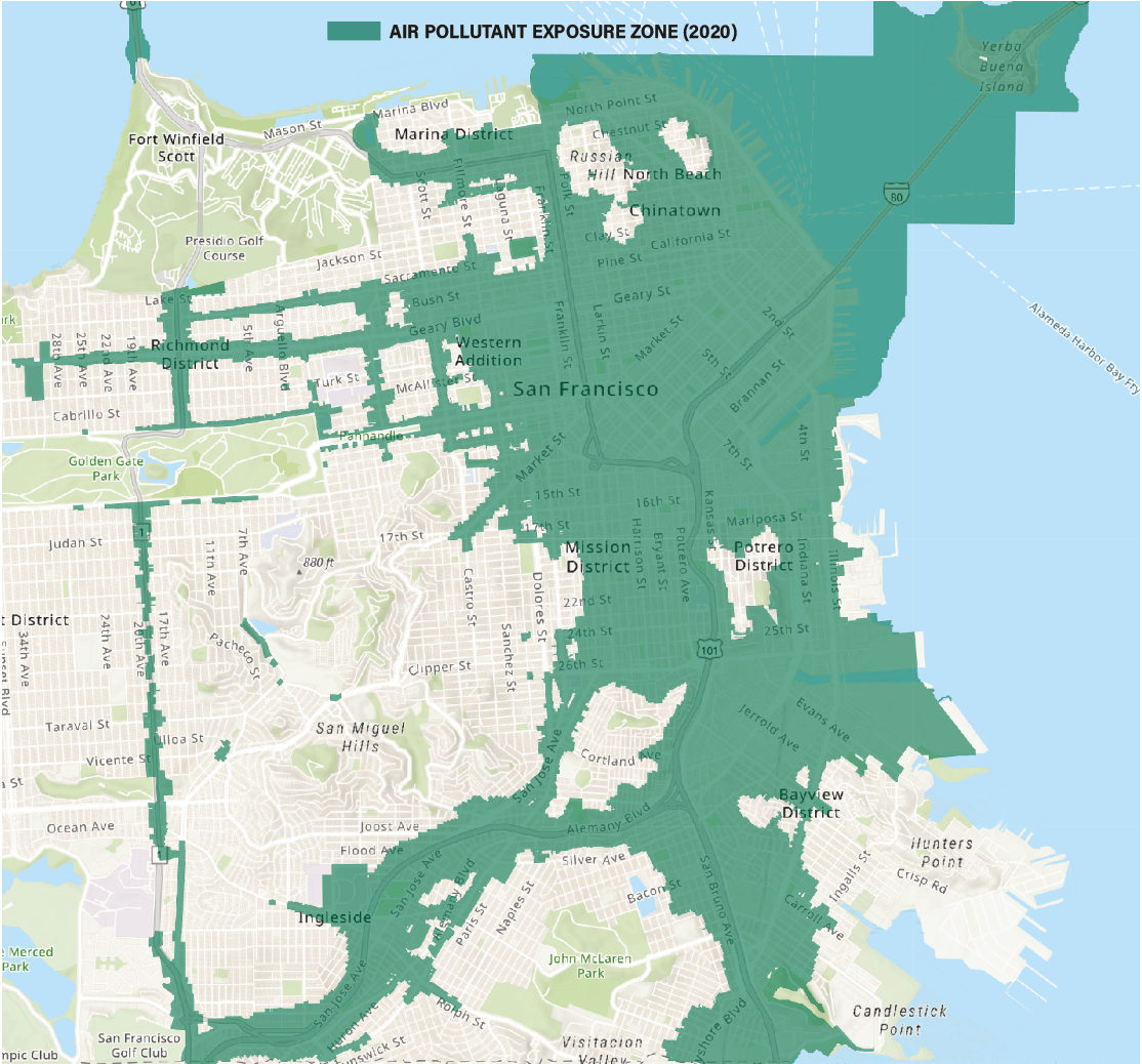
San Francisco requires new residential construction projects located within “Air Pollutant Exposure Zones” to implement enhanced ventilation systems to improve indoor air quality and safeguard residents’ health. Much of Dogpatch, Mission Bay and Potrero Hill is with such a zone, though an area centered around the Potrero Hill Recreation Center has cleaner air. Indoor air quality can be improved by installing HEPA filters, along with keeping windows closed during high pollution events such as wildfires and rush hour. Air quality monitors – like those made by PurpleAir – can be installed to measure pollution levels.
Low- or no-emission vehicles also reduce pollution, though toxins can be released by oils, tires, and other car parts. In 2022 California implemented Advanced Clean Cars II, which mandates that all new passenger cars, trucks, and sports utility vehicles (SUVs) be zero-emission vehicles (ZEV) by 2035. According to the California Air Resources Board, state residents quickly over-complied, purchasing nearly 450,000 new ZEVs in 2023, 30 percent more than the previous year. ZEVs accounted for 25 percent of new vehicle sales, up from 20 percent in 2022. As a result, California exceeded its goal of 1.5 million ZEVs two years ahead of schedule.
In May, at the request of the Trump Administration, the U.S. Congress revoked the E.P.A. waiver that allowed the state to enforce its ZEV regulations. Governor Newsom sued to restore it. E.P.A. Administrator Lee Zeldin then introduced a proposal to rescind the 2009 “endangerment finding,” which found that greenhouse gas emissions from vehicles contribute to climate change, harmful to humans, enabling the agency to regulate these forms of pollution under the Clean Air Act. If the Trump Administration is successful – the proposal is first open to public comment – greenhouse gas emissions from cars and trucks will no longer be subject to federal limits.
“Regardless of changes at the federal level,” Borrmann said, “the Bay Area Air District will continue to enforce the state and local regulations which remain in place.”
Image, top: Green indicates elevated air pollution levels, which are generally associated with vehicles, 2020 data. Source: https://air.health/