Add hunger to the list of things that’re booming in the Bay Area. The San Francisco-Marin Food Bank, which just purchased a 38,000-square foot facility in San Rafael and plans to expand its 65,000-square foot warehouse on Pennsylvania Avenue, estimates that 29 million meals are missed annually in the City alone.
“When we first moved into our building 20 years ago, we were distributing eight million pounds of food,” said Paul Ash, the Bank’s executive director. “Now we are distributing almost 50 million pounds of food and it’s still not enough.”
The Food Bank’s goal is to have enough capacity to distribute 70 million pounds from its San Francisco location. It already has the capability to bring in more food. “We just have nowhere to put it,” said spokesman Mark Seelig.
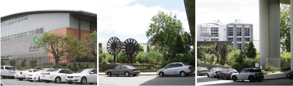
For the warehouse to expand, the Food Bank would have to reduce its parking area. To accommodate growth while retaining parking, Ash wants to turn a vacant lot on the southeast corner of Iowa and 23rd streets into a lot, an idea that troubles Dogpatch residents who had eyed the parcel for public use. Presently, the tract is a fenced-in overgrown green space that abuts Progress Park. It runs next to but isn’t under Interstate-280.
According to Julie Christensen, Dogpatch and Northwest Potrero Hill Green Benefit District (GBD) executive director, repurposing freeway parcels is a top community priority. “The concern now is that the City is green-lighting so much building close to the freeway and, as we build closer and closer to the freeway, the parcels around it become more important,” she said. “No one is looking at those parcels in a holistic way. There are a lot of parking lots around the freeway but not a lot of sunny open space.”
GBD first met with Ash two years ago to discuss the Iowa and 23rd streets lot, and did so again last month, along with Potrero Boosters and Dogpatch Neighborhood Association (DNA) members. The Food Bank has been leasing the lot from its owner, the California Department of Transportation (Caltrans) for the past three years; it recently secured a long-term agreement that would allow the nonprofit to invest in cleaning up and paving the space. Unless community groups quickly find an alternative site to meet the Food Bank’s needs, Ash’s plans will proceed.
On the northside of the Bank’s Pennsylvania Avenue warehouse there are two parking rows. The first line is mainly used for shop accounts, where some of the 409 community organizations with which the nonprofit partners come to pick-up food. The second row offers limited parking for the Bank’s 115 employees and 40,000 individuals who volunteer each year. Blacktop on the warehouse’s southside is used principally for truck parking and loading. Hovering above that area is a bent lamppost which one of the delivery trucks backed into.
“We’re constantly jockeying for position,” said Seelig. “It’s like a Tetris board here.”
The vacant lot became known as “Gears Parcel” after two large gears from the long-closed Tubbs Cordage factory were moved there when excavation began on the Abaca housing project. Susan Eslick, a GBD board member and DNA vice-president, noted that the tract is the only green space in the 23rd and Iowa intersection.
“We have tons of underutilized spaces under the freeways. Fine to use for parking and storage but when a Caltrans parcel is sunlit and usable, why make more parking?” she asked.
The other corners of the intersection house a Muni yard, Caltrain train trench, and a storage facility for Off the Grid, a food truck festival company. Although the City and County of San Francisco wants to move the Caltrain tracks underground, that won’t likely happen for another decade.
It’s become popular throughout the Bay Area to repurpose space near or under freeways for public use. San Francisco’s Central Waterfront Public Realm Plan suggests integrating such parcels into Dogpatch’s open space network by converting it into recreational usage, such the skate parks located South of Market under U.S. Highway 101.
Christensen said one possible use for the Gears Parcel would be to have The Ball Club Bruins, an organization that offers baseball instruction to youths, utilize the space. According to Derek Tate, the company’s president, “We’d like to build a multi-functional space that would be a great park to attract kids for baseball and for the community to use as well.” Tate noted that with many school teams limited to just one weekly practice due to field shortages, his business has picked up the slack by training up to 90 youths at any given time during the three years it’s been in existence. However, the Bruins only became involved in discussions over what to do with the Gears Parcel in March.
“We’d like a win-win-win,” said Eslick. “Food Bank gets what they need to operate; Caltrans makes more money leasing its parcels; neighborhood gets more green space.”
Last month, Indiana Street resident, Jeff Zacuto, emailed the Food Bank to ask that Ash work with residents to find an alternative outcome. “Over the last four years that I’ve lived in Dogpatch, the southern part of the neighborhood has shifted rapidly from industrial to mixed use, making it even more imperative that we preserve whatever land we can for public use,” he wrote.
Ash said he’d keep an open mind about the tract’s ultimate use, but noted that, while neighborhood advocates might view the parcel as a lost opportunity, he sees it as a chance to feed more people. “We’re moving ahead because we need the space,” he said, adding work would likely begin by year’s end. “I would never say we’re not open to something that’s equal or better. I’ve looked everywhere. We went through a list of properties. We have looked extensively in this part of San Francisco and we haven’t found anything else.”
According to Ash, the parcel is the minimum size to meet the Food Bank’s needs; any alternative would have to be walking distance from the Pennsylvania Street warehouse and easily developable, preferably flat.
Driving the need for the Bank’s expansion, said Seelig, is the Bay Area’s high cost of living, which gobbles up ever greater amounts of low income people’s food budget. In addition, since Donald Trump was elected President, the San Francisco Human Services Agency has detected a drop in Supplement Nutrition Assistance Program (SNAP) applications from eligible households that have at least one immigrant. The decline may impact children’s access to free school lunch programs, which are tied to SNAP entitlement.
Through deals with Central Valley farmers, last year 3.7 million pounds of potatoes, 2.8 million pounds of oranges and several million pounds of assorted fruits and vegetables made their way through the Food Bank’s warehouses. Most of its beneficiaries are children, seniors, unemployed individuals and low wage workers. Only 14 percent are homeless. The Bank delivers to 4,000 homebound residents, services 260 food pantries and provides morning snacks to schools.
