The sidewalk in front of the Strata at Mission Bay has dropped roughly six inches below the base of the mixed-use, market rate apartment building since it was erected in 2009. Work to repair the damage at 1201 Fourth Street was initiated last spring; a new sidewalk is being installed along the entire block. During construction pedestrians are rerouted into the parking lane off the curb, protected by orange posts to create a vehicle barrier.
Strata at Mission Bay was the first residential building constructed on Fourth Street in Mission Bay South, the second to open south of Mission Creek. Mission Bay’s sidewalks and streets have been installed incrementally, coinciding with the initial structure being erected along a particular block. Most of the roads and paths north of the University of California, San Francisco campus were completed in 2009, concurrent with the opening of the Strata on Block 4W.
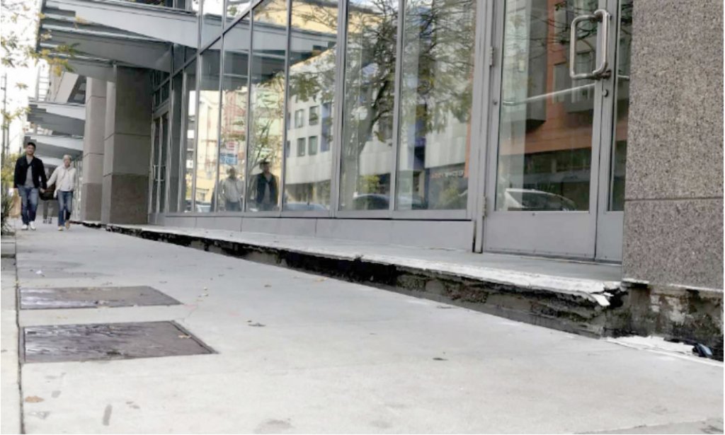

The Strata abuts the sidewalk property line without a setback or landscaped buffer to mitigate predicted sidewalk settlement. As a result, the footway pulled away from the base of the building’s façade when it settled, impeding access into and around it. By 2013, when Bimma Loft became the first retailer to open in Mission Bay, at 1245 Fourth Street, the sidewalk was so far below floor level that before the furniture store could open a wooden ramp had to be installed at the entrance to comply with the Americans with Disabilities Act.
PowerPlay and The UPS Store opened more recently in those storefronts, also with wooden ramps for ADA compliance. Entrance to those businesses during reconstruction is through a door on China Basin Street that leads to a corridor behind the retailers.
All of Mission Bay is subject to subsidence, or settling. The 303-acre development is built on fill. Old maps and photographs show water where inland creeks and estuaries drained into a wide basin that stretched from South-of-Market to Potrero Hill’s northern foot.
“Settlement of sidewalks was expected, and predicted by the geotechnical engineering analysis of the site,” said Luke Stewart, Director of Design and Planning for Mission Bay Development Corporation. MBDG builds the public streets and sidewalks, known as “horizontal development”, per municipally-mandated specifications from agencies such as the San Francisco Department of Public Works and San Francisco Public Utilities Commission.
“The settlement along Fourth Street is consistent with the predictions of the geotechnical analysis,” Stewart added. “The original Mission Bay master planning, grading plans, and infrastructure and utility designs all took into account and accommodated for the anticipated future settlement around the site.”
While developers were aware of the likelihood of subsidence, they didn’t always take corrective action during construction. Building to the sidewalk line isn’t a good strategy in Mission Bay. As expected sinking occurs, the resulting height variant or vertical gap between the pathway and edifice inevitably creates a tripping hazard for people entering the structure, as evidenced at the Strata.
“Case Studies in Mission Bay, San Francisco: Deep Foundations in Challenging Soil Conditions”, published in the 2006 Deep Foundations Institute Proceedings, states that Mission Bay’s subsurface consists of fill, bay mud, Colma sand, old bay clay, sand and clay, and Franciscan formation bedrock. DFI is an international technical association of firms and individuals involved in the deep foundations and related industries.
“Settlement is expected to occur unevenly, depending on the underlying soil stratigraphy and the amount of additional fill used to regrade in any given area,” Stewart said. “The rate of settlement depends on the thickness of the Bay mud below, and the rate of settlement does slow over time.”
Paths and roads are engineered for settlement, depending on underlying soil conditions. “Prior to the engineering and design of the streets and sidewalks, core-drilled soil samples taken around the site allowed geotechnical engineers to characterize subsurface soil types and engineering parameters and perform analyses to predict the settlement,” Stewart added.
All Mission Bay buildings are supported on piles, and don’t experience significant settlement. Private edifices and the underlying piles, known as the “vertical development”, are permitted by the San Francisco Department of Building Inspection.
Foundations pile-driven to bedrock are an important feature. The Millenium Tower, at 301 Mission Street, was built on piles that stop in sand 80 feet below the surface, instead of being driven into the bedrock below. The well-publicized result has been that the Millenium is tilting. Its settling has been more severe and occurred at a rate much faster than anticipated.
Sidewalk settling has occurred elsewhere in Mission Bay, and is especially noticeable around MB360, a mixed-use market rate apartment building at 1200 Fourth Street. MB360 was completed in 2016, after a 2014 fire demolished the first structure at the site and delayed construction. In its first three years, a height variance of a couple of inches has opened between the structure and sidewalk. A strip of white paint, dots and arrows have been applied to warn pedestrians of the tripping hazard.
In 2017, after a senior person sustained broken bones from a fall while entering the Reveille Café at 610 Long Bridge Street, neighborhood residents brought attention to the need for sidewalk reconstruction where tripping hazards existed. As a result, the standard concrete sidewalk will be replaced with adjustable sidewalk pavers in front of the building.
At some sites where significant sidewalk or street settlement is anticipated, private property owners have designed and built-in setbacks at the ground floor, to maintain safe access into the building as the predicted sinking occurs. These setbacks or landscaped buffers enable the proprietor to make incremental grading adjustments over time.
Sea level rise also has the neighborhood’s attention. The Port of San Francisco has partnered with the United States Corps of Army Engineers and several municipal departments to evaluate how to protect existing and planned infrastructure, such as public transportation, emergency response and police facilities, and utilities near the eastern waterfront, as well as the aesthetic and quality of life features of neighborhoods like Mission Bay.
As part of the analysis, which’ll be completed within five years, the Port is holding a series of community meetings. March gatherings, collectively attended by roughly 160 people, focused on sea level rise near Mission and Islais creeks. Participants were asked what they loved most about the waterfront; what City assets are most important; and, if disaster strikes, what’s of biggest concern.
“The purpose of having the Port engage members of the local community early in the process is to get input on the things that are important to people who live, work and recreate here,” Lindy Lowe, Port Resilience Officer, explained. “We need to balance (infrastructure) out with a large community consensus. How people feel about the Bay, the creek, and the walking trails. The creek is a valuable asset to the neighborhood.”
“One of the things we’re going to be doing with the Army Corps is refining the understanding of the flood risks,” Lowe said. “On a flood study model of what the Army Corps has done on flood studies back east, they will put in our topography, and our conditions, for example we don’t have hurricanes but we do have different kinds of storms, to determine where we are going to have flooding events. We’re going to have intermittent flooding before we have permanent flooding. We’ll be really focused on identifying where flooding is going to occur. We’re working closely with SFMTA and the Planning Department’s Transportation Team, and the San Francisco County Transportation Authority, which is involved with congestion in the City, as well as some of our regional transportation agencies.”
Study funding comes from 2018’s Proposition A, a $425 million general obligation bond to support planning, design, engineering and construction management for earthquake resiliency projects, such as retrofitting and replacing the 100-year-old Embarcadero Seawall that protects three miles of the waterfront, from Fisherman’s Wharf to the ballpark on the north bank of Mission Creek.
“The work that we are doing for the Army Corps flood study has been broken up into three geographies — Embarcadero Seawall Segment (Fisherman’s Wharf to Mission Creek), Mission Bay, and Islais Creek — for the purposes of engagement, problem and opportunity definition and strategy development,” Lowe said. The bond money provides San Francisco with two important components pertaining to the flood study; it demonstrates local commitment to addressing the problem, which makes it easier to attract federal and state resources, and it provides match funding for the work that we are doing within the Seawall Program segment.”
The Port will continue its outreach efforts throughout the year.
